Walking to Neuwerk Across the Wadden Sea: A Practical Guide for 2026
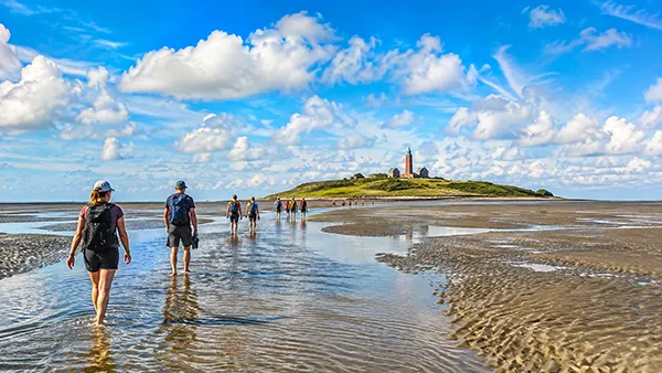
Walking from the German mainland to the island of Neuwerk is one of the few journeys in Europe where the road effectively appears when the sea retreats. At low tide, large sections of the Wadden Sea between Cuxhaven and Neuwerk become accessible on foot, allowing walkers to cross mudflats, shallow tidal channels and firm sandy ground before reaching the island. The route is unusual but it should not be treated as an ordinary beach walk. Tides determine when the crossing is possible, weather can change conditions quickly, and parts of the seabed may remain wet even during low water. With sensible preparation, suitable footwear and careful timing, the walk offers a practical way to see the tidal landscape at close range while travelling to one of Hamburg’s most remote districts.
Planning the Walk from Cuxhaven to Neuwerk
The most common starting point for walkers is Sahlenburg, a coastal district of Cuxhaven. It provides the shortest established route across the mudflats to Neuwerk. The marked crossing is approximately 10 kilometres long, although the actual distance covered can vary slightly depending on the route through tidal channels and the conditions underfoot. Most walkers need around two and a half to three and a half hours to reach the island. This makes the journey manageable for people with a reasonable level of fitness, but the soft surface requires noticeably more effort than walking the same distance on a road or conventional hiking trail.
Timing is the most important part of planning. A suitable departure time cannot be chosen simply by looking at the time of low tide and starting whenever convenient. Walkers need enough time to reach Neuwerk before the incoming water makes sections of the route unsafe or impassable. Water levels are also influenced by wind and weather, so the conditions on a particular day can differ from what a visitor might expect from the tide table alone. For this reason, current local information should always be checked shortly before departure rather than relying on a timetable saved several days earlier.
Guided walks are a sensible option, particularly for a first crossing. Local mudflat guides plan departures around tidal conditions and know which channels, surfaces and sections of the route require extra attention. The Nationalpark-Haus Neuwerk continues to organise guided activities during the 2026 season, although individual tours can be moved or cancelled when weather conditions make them unsuitable. Travellers planning independently should apply the same level of caution: if visibility deteriorates, thunderstorms are forecast or local advice indicates that the crossing should not be attempted, the walk should be postponed.
Choosing the Right Time and Equipment
The main walking season is generally associated with the warmer part of the year, when conditions are more suitable for spending several hours exposed to wind and water. Even in summer, however, temperatures on the mudflats can feel considerably lower than they do in sheltered parts of Cuxhaven. Wind has little to block it, and clothing can become wet while crossing tidal channels. Lightweight layers, a windproof or waterproof outer layer and a change of dry clothing in a protected bag are therefore more useful than dressing only for the temperature shown in a general weather forecast.
Footwear deserves particular attention because the seabed is not consistently soft mud. Walkers encounter wet sand, firmer areas, shells and shallow channels along the way. Proper mudflat or water shoes that stay securely on the feet are usually more practical than ordinary sandals. Walking barefoot for the entire crossing is not a good choice because sharp shell fragments can cause cuts, while loose footwear may be pulled off in softer sediment. In cooler conditions, suitable boots may be preferable, but they still need to cope with sections where the water rises above ankle level.
A small backpack should contain drinking water, food, sun protection, weather protection and a fully charged mobile phone. A waterproof bag or internal dry pouch is useful for electronics and spare clothes. Travellers should also carry the day’s tidal information rather than depending entirely on mobile reception. Heavy luggage is best avoided because every extra kilogram becomes more noticeable after several kilometres over uneven ground. Anyone who has difficulty walking for three hours, has limited balance or is travelling with very young children should consider a guided trip or a Wattwagen instead of assuming that the crossing will be as easy as a normal 10-kilometre walk.
What the Route Across the Wadden Sea Is Really Like
The route from Sahlenburg is marked across the tidal flats, traditionally with rows of brushwood markers known locally as Pricken. They provide orientation over a landscape that can otherwise look remarkably uniform. Following the established route is important even when Neuwerk appears clearly visible in the distance. A direct line towards the island is not necessarily a safe line because tidal channels cut through the seabed, and apparently shorter sections may contain softer sediment or water that is deeper than expected. The marked route reflects the practical way across the flats rather than simply the shortest geometric distance.
The surface changes repeatedly during the walk. Near the coast, walkers may pass over broad stretches of wet sand before reaching softer areas and shallow channels. Some parts feel almost like a firm beach, while others require slower steps because the feet sink into the sediment. Crossing water is a normal part of the journey. Conditions can also vary from one day to another as currents reshape small channels and move sediment around the Wadden Sea, which is another reason why descriptions from previous trips should not be treated as exact instructions for a later crossing.
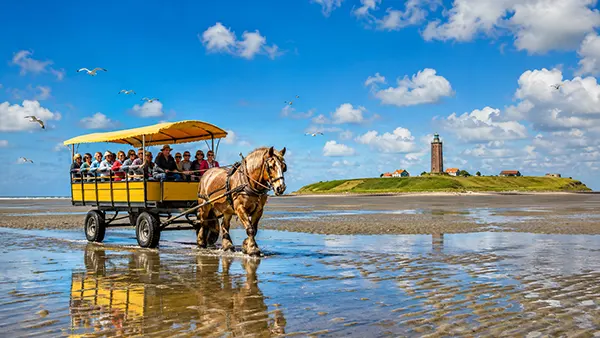
The landscape is open enough that distance can be deceptive. Neuwerk may remain visible for much of the journey, yet it can appear to come closer very slowly. Wattwagen horse-drawn carriages often use routes across the same broad tidal area, providing a useful sense of scale. Walkers should maintain a steady pace rather than spending long periods stopping for photographs or wildlife observations. Low tide provides a limited travel window, and losing twenty or thirty minutes early in the walk can reduce the safety margin later when the route approaches deeper channels or the water begins to return.
Why Tides and Weather Matter So Much
The Wadden Sea changes character twice each tidal cycle. Areas that look like enormous open beaches at low tide are later covered by the North Sea. The change is not always visually dramatic at first. Water may begin filling channels and depressions before the surrounding flats appear noticeably flooded, which can cut off a route earlier than an inexperienced visitor expects. An incoming tide should therefore never be judged only by watching the waterline. The safe walking period is based on local tidal knowledge and sufficient time to complete the entire crossing.
Weather adds another variable. Strong winds can influence water levels, while fog, heavy rain and thunderstorms can turn a straightforward outing into a much more difficult situation. The exposed landscape offers almost no natural shelter. Fog is particularly problematic because familiar landmarks can disappear very quickly. Emergency and rescue services operate in the Cuxhaven mudflats, but their presence should not be treated as a substitute for proper planning. Cuxhaven’s fire and rescue service regularly deals with people who have been surprised by the incoming tide, illustrating why conservative timing is more important than trying to complete a planned trip at all costs.
If conditions become questionable before departure, changing the day’s plan is the sensible response. Visitors can still experience the Wadden Sea on shorter guided walks near Cuxhaven without committing to the full route to Neuwerk. A Wattwagen journey may also be available on appropriate tidal days. The key distinction is that the seabed is part of an active tidal environment rather than a permanent hiking path. Good preparation therefore means accepting that nature determines whether the trip goes ahead, even when accommodation, transport or other arrangements have already been made.
Reaching Neuwerk and Planning the Return Journey
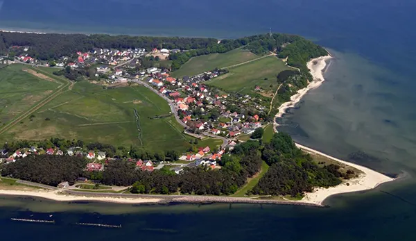
After several hours on the flats, reaching Neuwerk feels markedly different from arriving on an island by ferry. The island covers only around three square kilometres and belongs administratively to Hamburg despite lying much closer to Cuxhaven than to central Hamburg. It forms part of Hamburg Wadden Sea National Park, within the wider Wadden Sea UNESCO World Heritage area. Once walkers leave the mudflat route, they enter a low-lying landscape of dykes, salt marshes and small settlements where the pace is very different from that of Germany’s major coastal resorts.
The Nationalpark-Haus Neuwerk is one of the most useful stops after the crossing. It provides information about the formation of the Wadden Sea, local wildlife and the neighbouring islands of Scharhörn and Nigehörn. Birdlife is particularly important here because the protected tidal flats and salt marshes provide feeding and resting areas for numerous species. Visitors should stay on permitted routes where required and respect seasonal protection zones rather than walking freely across sensitive vegetation simply because an area appears accessible.
Neuwerk’s best-known landmark is its historic tower, completed in 1310 and regarded as Hamburg’s oldest secular building. Visitors in 2026 should be aware that the structure is undergoing a major heritage restoration. Work on the façade began in June 2026, with further interior work scheduled from autumn and the wider project expected to continue until 2028. The tower therefore remains an important part of the island’s skyline and history, but a trip in 2026 should not be planned around the assumption that normal visitor access or its former hospitality functions will be available.
Returning by Ferry, Wattwagen or on Foot
A return journey should be arranged before setting out from Cuxhaven. Many walkers cross the mudflats in one direction and use a ferry or Wattwagen for the other, which avoids having to fit two long walks into separate low-tide windows on the same day. Ferry services from Neuwerk are tied to tidal conditions, so departure times do not follow the kind of fixed daily pattern familiar from conventional island routes. The timetable for the exact travel date should be checked in advance, and reservations are sensible when the chosen service allows or requires them.
Returning by Wattwagen offers a different view of the same tidal landscape. These traditional horse-drawn carriages operate between the Cuxhaven area and Neuwerk when water levels permit. They are not simply sightseeing vehicles running continuously throughout the day; their movements also depend on the tide. Travellers combining walking with a carriage journey should therefore treat the booked departure as a firm part of the itinerary and leave enough time on Neuwerk to reach the meeting point without rushing.
Walking both ways is possible only when tidal timing, weather, fitness and an appropriate itinerary make it realistic, and it should not be treated as the standard option for a first visit. Staying overnight can create more flexibility, but accommodation on the small island is limited and should be arranged well ahead during busy periods. For most visitors, walking from Sahlenburg to Neuwerk and returning by an organised transport option provides the most balanced day: it preserves the distinctive experience of crossing the Wadden Sea on foot while avoiding unnecessary pressure to race a second tidal window. Checking the latest tide, weather and transport information immediately before the trip remains the final and most important part of planning.